This project detects and counts Oil Palm Trees in Drone Images.
Pinaki Nath Chowdhury, Palaiahnakote Shivakumara, Lokesh Nandanwar, Faizal Samiron, Umapada Pal
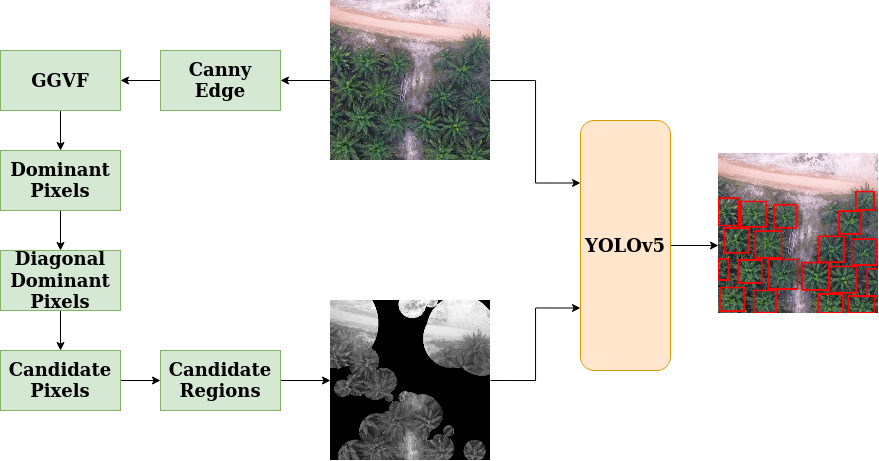
When the images are captured by drones in oblique angles, palm tree detection is challenging. This paper presents a method towards palm tree counting using a novel idea of detecting dominant points by exploring Generalized Gradient Vector Flow, which defines symmetry based on gradient direction of the pixels. For each dominant point, we use angle information for classifying diagonal dominant points. The proposed method expands the direction of diagonal dominant points until it finds intersection point with another diagonal dominant point. The step works based on the fact that the direction of the branches of tree meet at center of tree. This step results in candidate points. For each candidate points, the proposed method constructs the ring by considering the distance between intersection and nearest neighbor candidate point as radius. This outputs region of interest, which includes center of each tree in the image. To remove false positives, we explore deep learning YOLOv5 architecture that counts oil palm tree in the drone images irrespective of tree type of palm family. Experimental results on our dataset of the images captured by drones and standard dataset of coconut images captured by UAV (Unmanned Aerial Vehicle) of different trees show that the proposed method is effective and better than SOTA methods.
Click to view the Block Diagram
Click to view the yolov5 Network Architecture
git clone https://github.com/pinakinathc/oil-palm-detection.git
conda env create -f environment.yml
Go to ggvf_gvf directory using cd ggvf_gvf/
Keep your input images inside sample_images/ directory and run matlab -batch pinaki. This will generate the ggvf results in ggvf_output/ directory.
Go to the ggvf_output/ directory and rename all *.mat files to *.jpg using the command: rename 's/.mat/.jpg/' *.mat
Go to root directory and evaluate the candidate regions using: python main.py enter/path/to/dir/with/RGB/input/images enter/path/to/dir/with/ggvf/images --vis_save_path path/to/save/candidate/images
Use these results from main.py as input to yolov5 following the instruction in README.md file present in yolov5 dir.
Big thanks to ultralytics for sharing their code
Clean code
Add authors names
Upload trained model weights
This code is only for academic purpose. For commercial purpose, please contact: contact[at]pinakinathc.me
Contact details of other authors will be updated soon.